Day 133-136: Crossing from Oregon into Washington

20120907-215613.jpg

Day 133: Little Zigzag Canyon (Mile 2109)-Buck Peak (Mile 2132.5); 23.5 miles

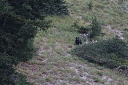
During our morning’s walk, we were excited to see a black bear bounding across the hillside above us. It’s amazing how fast and graceful bears can be, given their size and weight. The bear paused briefly to stare at us, then continued running.

20120907-215716.jpg

We walked through terrain carved deeply by rivers flowing off Mt. Hood. At Sandy River, we crossed a small log bridge with log poles at either end. The bridge featured a string to grab for stability, and a boot stuck on each pole for decorative purposes.

Day 129-132: Snow Fields to Sand Dunes

20120831-122458.jpg

Day 129: Near North Cinder Peak (Mile 2025.5)-Near Ruddy Hill (Mile 2049); 23.5 miles

A doe and her fawn visited us early in the morning, snacking on some of the nearby flowers.

20120831-114808.jpg

In a few miles, we reached Russell Creek. Our map marked this creek as a possible ford. We were surprised to find the creek buried under a few feet of snow. Instead of walking through the water, we walked above it on a snow bridge. A solid snow bridge works as well as a wooden one.

Day 125-128: Picturing the Three Sisters Wilderness

In the past four days, we witnessed some of the most beautiful and varied scenery the Pacific Crest Trail has to offer. Below we share the visual story of our journey through the Three Sisters Wilderness, Mt. Washington Wilderness, and Mt. Jefferson Wilderness. Happy viewing!

Day 125: Desane Lake (Mile 1948)-Near Rock Mesa (Mile 1970); 22 miles

20120826-161956.jpg