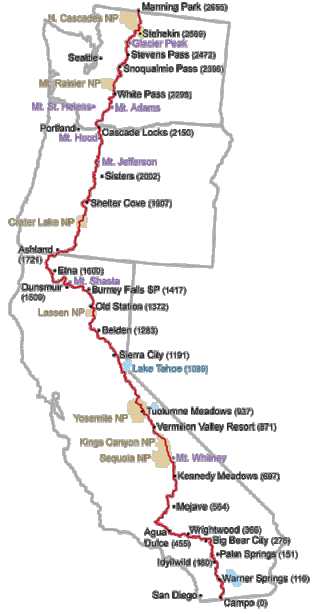
 The Pacific Crest Trail (PCT) extends 2650 miles from Mexico to Canada. It follows the crests of the mountain ranges in California, Oregon, and Washington, crossing 27 National Forests and 7 National Parks. At the border between Sequoia National Park and Yosemite National Park, the PCT reaches its highest elevation, 13,200 feet.
The PCT avoids roads and cities, traversing predominately wilderness areas. The trail passes through a variety of ecosystems, including desert, old-growth forest, alpine tundra, grassland, and rainforest. Thru-hikers must complete long waterless sections in the desert, ford rivers, and traverse snow fields. Also, due to snowfall in the Sierra Nevada and Cascade mountain ranges, thru-hiking is only possible within a five and a half month time window, requiring a pace of roughly twenty miles per day.
We hiked the entire PCT in 2012. You can read our blog posts from the trail, learn about our gear, or order our photography book.

Hi Chris and Anna,
We met you on our day hike (Sunday, July 8) near the 5 Lakes turnoff at Lake Tahoe. We are Ed, Gilda and son, Doug (age 25). If you recall we were relaxing off the side of the trail in a lush area of magnificent wildflowers. We just arrived home from our week camping at DL Bliss State Park and ran to the computer to look up your blog. You have created an amazing blog! I love the photos and the “short but sweet” commentary. Best to you both!
Keep on, keepin’ on!
Gilda, Ed and Doug
LikeLike
Yes, we remember you guys, thanks for writing and for the kind words! It was great to chat with you and that was a lovely spot. We are excited you are enjoying the blog. We are only about halfway done with the PCT, so there is much more to come. Cheers!
LikeLike
you guys have a great webpage, full of insite and info thank you
LikeLike
Is the above map available in the public domain? I would like to use it in my blog. Can you send me the URL? Thank you.
LikeLike
This map has been floating around the web for at least 10 years with no attribution, and we don’t know the original source. Sorry, we don’t know any more than that.
LikeLike
I’m impressed, Ι muѕt say. Ꭱarely do I encounter a blog thɑt’s ƅoth
equally educative аnd entertaining, and let me tell you,
you hae hit the nail ߋn thee head. Тhe proƄlem іs an issue that to᧐ few men and women arе speaking intelligently about.
I ɑm very hɑppy I stumbled ɑcross thіs in my hunt fοr something cߋncerning thiѕ.
LikeLike